maps

Stephen King's stories exist in the same universe

I've never been a huge Stephen King fan - I've only read a small handful of his novels, but I am a huge fan of his memoir, On Writing. It might even be in my top five of all time . . . including all genres. 

Non the less, I admire him immensely. His skill, his approach and dedication to the craft, and his imagination are, in many ways, unmatched. This short video only hints at the complexity of his mind, and the vast universe he has been able to create.


For more on . . .

-N- Stuff  :  Stephen King  :  Maps of favorite fictional worlds

10 Maps that will Challenge the Way you see the World

(via)

(via)

Matadornetwork.com published 57 MAPS THAT WILL CHALLENGE WHAT YOU THOUGHT YOU KNEW ABOUT THE WORLD and the results are pretty interesting, shocking, and insightful. But really, the underlining truth is this: Canada is the best place to live and a well constructed map is crazy fun to look at. And educational. 

And according to West Wing, maps have radically shaped the way we view the world - unfairly so.

Here are 9 of Matadornnetwork's 57 maps (1 from waitbutwhy) that can WoW us, challenge us, and reveal us:


1. There's an equal number of people in the blue and red areas


2. Countries that don't use the metric system

 Those other countries are Liberia and Myanmar (Burma). (via)

 Those other countries are Liberia and Myanmar (Burma). (via)


3. World air travel routes

This map includes only the arcs made in air travel routes. (via)

This map includes only the arcs made in air travel routes. (via)


4. Freedom of press map

From 2012, this map outlines the relative freedoms of press per country of the world.(via)

From 2012, this map outlines the relative freedoms of press per country of the world.(via)


5. South-north world map

Breaking from the long-held convention of orienting north as “up” established by Ptolemy (90-168 AD), and resulting from the majority of cartography taking place in the Northern Hemisphere, this world map seems turned on its head (by orienting south…

Breaking from the long-held convention of orienting north as “up” established by Ptolemy (90-168 AD), and resulting from the majority of cartography taking place in the Northern Hemisphere, this world map seems turned on its head (by orienting south as up). Fun fact: Evidently in the Middle Ages, cartographers routinely fixed east as up, “to orient.” (via)


6. Global internet usage based on time of day

With that orange upside-down “U” representing daylight hours, and a color spectrum spanning from red to blue (red indicating usage increase above average, blue indicating a usage decrease), this gif-map is visually stunning, but perhaps not terribly…

With that orange upside-down “U” representing daylight hours, and a color spectrum spanning from red to blue (red indicating usage increase above average, blue indicating a usage decrease), this gif-map is visually stunning, but perhaps not terribly surprising. (via)


7. World map of countries England has not invaded

Of the 196 countries of the world today, there are only 22 of them that Britain has not invaded, though only 21 appear on this map (suspiciously absent is the island nation of Sao Tome and Principe). (via)

Of the 196 countries of the world today, there are only 22 of them that Britain has not invaded, though only 21 appear on this map (suspiciously absent is the island nation of Sao Tome and Principe). (via)


8. US auto-complete map

With the recent success of “crowdsourcing” for everything from ideas, to products, to scientific data, it would be difficult to deny there must be some horrifying truth to the information in this map. Populated by searching “State name is…” in Yahoo…

With the recent success of “crowdsourcing” for everything from ideas, to products, to scientific data, it would be difficult to deny there must be some horrifying truth to the information in this map. Populated by searching “State name is…” in Yahoo and allowing the “topmost satisfactory result” to represent each state, this map illustrates exactly what the internet seems to think about the states, and the US as a whole. (via)


9. US map of the highest-paid public employees by state

Clearly, America loves its football, to the tune of $5,545,852.00 (Head Coach Nick Saban of Alabama’s 2013 salary). (via)

Clearly, America loves its football, to the tune of $5,545,852.00 (Head Coach Nick Saban of Alabama’s 2013 salary). (via)


10. US in seven deadly sins

While I don’t wholly agree with the criteria used to compose each sin-map, it was interesting to see the distribution of average income compared to the poverty line, total theft, number of violent crimes, entertainment expenditures, fast-food restau…

While I don’t wholly agree with the criteria used to compose each sin-map, it was interesting to see the distribution of average income compared to the poverty line, total theft, number of violent crimes, entertainment expenditures, fast-food restaurants, number of STD cases, and an aggregate of the lot in a plain and clear representation. It would seem that Iowa is the most “saintly” by these standards. (via)


Click here for maps of our favorite fictional worlds, an infographic of how the world reads, or posts about random things you might find interesting. 

Thanks for reading!

Mapping US Presidents

Wait But Why published this map in his two-part blog, "It's Going to be Okay." 

Dividing the two groups of men by political parties seemed too simple - almost unfair.

So I Googled "maps of US Presidents" and found this one:

The Washington Post printed this one:

Both were enlightening in terms of how closely most of our presidents were raised and educated and in which part of the country seems to raise up presidential leaders, but neither gave a deeper understanding in terms of specifics - did all republican presidents come from the south? Can a state produce a president from both parties? Is our country divided so simply?

This one gave a bit more clarity:

The Washington Post also added this, A few interesting observations:

* Ohio is the birthplace of seven presidents, second only to Virginia's eight. But, Ohio hasn't elected a president since Warren Harding in 1920. And Harding didn't even last a full term, dying in 1923. (Random Warren Harding factoid: His size 14 shoes were the largest of any president.)

* Texas' two native-born presidents aren't who you think they are.  Neither George H.W. Bush (Massachusetts) nor George W. Bush (Connecticut) were born in the Lone Star State. The two? Lyndon Johnson and Dwight Eisenhower. (Eisenhower was born in Denison, Texas.)

* Vermont is the smallest state with the biggest presidential punch as the birthplace of both Chester Arthur and Calvin Coolidge.

* California has produced only a single president -- and it was Republican Richard Nixon.

From these simple maps, I wonder if a few more observations, or perhaps reminders, can be made:

* Defining a man or woman based on their political party is too simple and unfair

* We may disagree on many things, but we are all united on at least on BIG thing - we're all Americans, and we all want what's best for our country.

* Although Hillary may not have been the best fit, it is time for a female president

* We've survived many presidents, good and bad, and have endured several hardships. There's no reason to think we won't continue to do so.

* Unless we fail to come together, when we forget that we're white and black and everything in between, We are protestant, Jew, gentile, Muslim, and atheist. We're Republicans. We're Democrats. And we're neither. But above all, we're Americans. And above even that, we're human.

* When we allow the smaller differences to define us, we lose sight of all that we have in common. And when we simplify the larger differences, we ignore the many small and beautiful ways that we are similar. 

Maps of Favorite Fictional Worlds

For months and years, sometimes decades, we live in these worlds - in both books and movies. But sometimes, its hard to connect the dots, of where each place is located, of what it looks like as a whole. Here are some great interpretations of our favorite worlds.

J.R.R. Tolkein

The Hobbit (from The Awl)

This map of Frodo’s journey if he had Google Maps (from Buzzfeed).

Suzanne Collins

Hunger Games (from Livejournal)

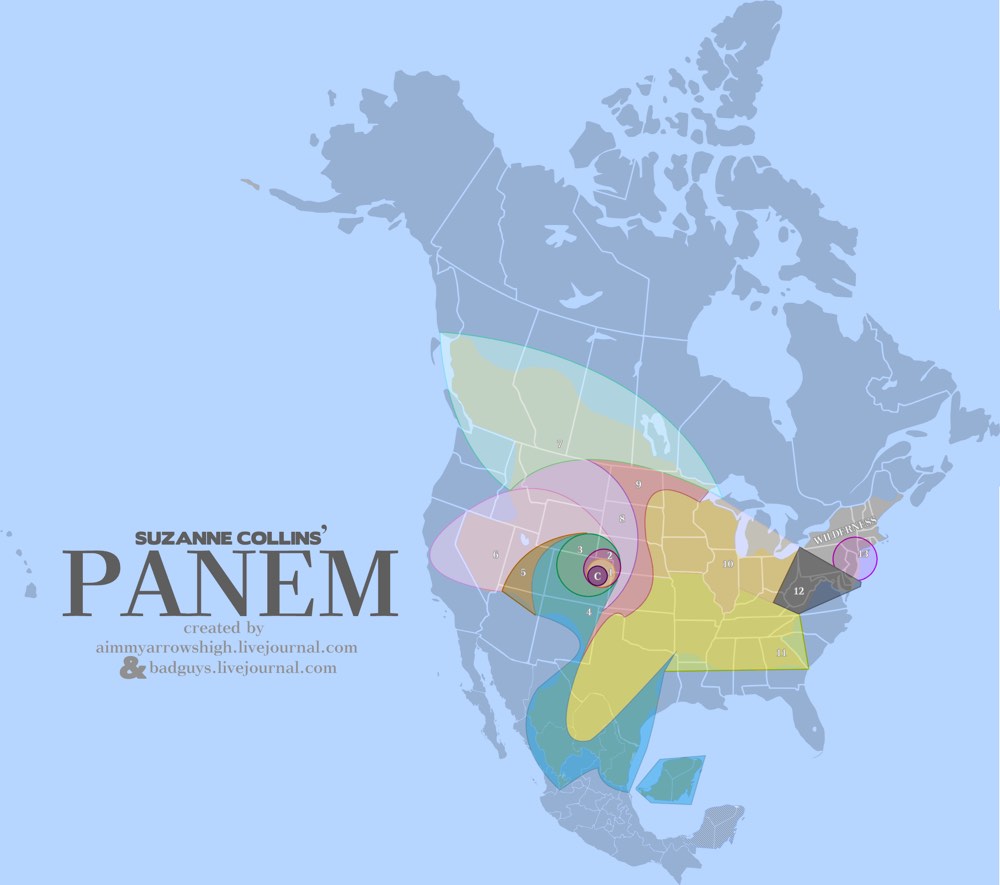
The Capitol is in Denver.

D12 is Appalachia.

D11 shares a border with D12, is one of the largest districts, is South of D12, and is primarily used for growing grain and produce.

D10 is primarily used for raising livestock. They do NOT process the livestock in D10. However, to feed an entire nation, D10 is likely another very large District.

D9 processes food for the Capitol and the tesserae; therefore, it likely shares borders with the food production Districts (D4, D10, D11).

D8 produces and treats textiles and is a factory District. It is POSSIBLE to reach D12 from D8 on foot over a course of weeks/months. Therefore, it does not cross a large body of water.

D7 specializes in lumber. It's probably large. It has no role in food processing or manufacture.

D6 works closely with the Capitol in the research and manufacture of drugs (morphling, medicines). It likely has close ties to D5 in the production of mutts.

D5 is entirely dependent on the Capitol, so it's probably somewhat nearby, and specializes in genetic research and manipulation. Because of the necessity of creative thought and intellect, it's most likely a smaller District so that it's easier to monitor and control.

D4 is the ocean. It does have a role in food production. It's very large. It is a Career District, so it likely is near the Capitol and has some self-sufficiency, but not enough that it doesn't engender loyalty. (Aside from that, D4 = perfect.)

D3 has extremely close ties to the Capitol and works with electronics and technology. It is likely small, the Capitol can closely monitor its scientific minds. It has no role in food manufacture or processing.

D2 specializes in weaponry, is the most loyal District (because the Capitol needs to keep its weapon specialists happy, non?), and has no role in food production. D2 also works in some minor Mining elements and trains Peacekeepers. The Panem railroad is easily accessible in D2.

D1 produces luxury goods for the Capitol -- INCLUDING having a diamond mine.  Kelsey Lake Diamond Mine is a defunct diamond mine in Colorado, USA. It is located in the State Line Kimberlite District, near the Wyoming border.

D13 specialized in nuclear power, shares a border with D12, is both visible and reachable from D12 by foot, and is North of West Virginia. Three Mile Island was in New YorkPennsylvania, and probably remained a nuclear reactor or was co-opted again as a reactor. D13 is small but mighty and is surrounded by Wilderness. It is self-sufficient.

A.A. Milne 

Winnie the Pooh (from the Awl)

L. Frank Baum

Wizard of Oz (from Buzzfeed)

from the awl

J.K. Rowling

Hogwarts (from tumbler)

William Goldman

The Princess Bride

Walt Disney

The location of Disney movies around the world (from buzzfeed)

George Orwell

1984 (from buzzfeed)

According to the Washington Post, sales of Orwell’s ‘1984’ have spiked since Kellyanne Conway’s ‘alternative facts’ speech. 

A map of the galaxy depicted in the Star Wars movies (from buzzfeed)

Mark Twain

Adventures of Huckleberry Finn (from The Huffington Post)

And if they all existed together, as they often do in our minds and conversations, the world might look like this: